Professional Drone Services in Dunedin & Otago
OCON Group provides professional drone mapping and aerial surveying services throughout the Dunedin, Queenstown and wider Otago region. Our drone technology delivers precise data capture for civil construction, earthworks, and site development projects.
With years of experience in the construction industry, we understand exactly what data our clients need. Our drone services integrate seamlessly with our civil construction and earthworks capabilities, providing end-to-end solutions for projects of all sizes across Dunedin and the surrounding areas.
Why Choose OCON Drone Services?
- Local Dunedin-based team with regional expertise
- Integration with civil and earthworks projects
- High-precision GPS-enabled equipment
- Fast turnaround on deliverables
- Competitive pricing for Otago projects
- Experienced, qualified operators
Aerial Mapping & Site Surveying
Our drone aerial mapping services capture detailed site information quickly and accurately. Using GPS-enabled drones, we produce high-resolution orthomosaic maps, topographic surveys, and digital terrain models for construction and development projects across Dunedin and Queenstown.
- Orthomosaic mapping and aerial photography
- Topographic surveys and contour mapping
- Digital Terrain Models (DTM) and Digital Surface Models (DSM)
- Site boundary and feature mapping
- Pre-construction site documentation
- As-built verification surveys
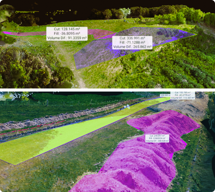
3D Modelling & Volumetric Analysis
Our drone technology enables accurate 3D modelling and volumetric calculations for earthworks, stockpile management, and construction planning. This data integrates directly with our Trimble Site Vision Grade Control systems for precise excavation work.
- 3D site models and digital elevation maps
- Stockpile volume measurements
- Cut and fill calculations
- Earthworks quantity verification
- Progress tracking against design models
- Export to CAD and construction software
Construction Progress Monitoring
Regular drone flights provide visual documentation and progress tracking throughout your project. Our services help project managers, contractors, and clients stay informed with accurate site imagery and progress reports.
- Regular progress photography and video
- Time-lapse documentation
- Site inspection and condition assessment
- Project milestone documentation
- Stakeholder reporting imagery
Industries We Serve in Dunedin & Otago
- Residential and commercial construction
- Civil infrastructure and roading projects
- Subdivision development
- Earthworks and site preparation
- Drainage and utility installation
- Demolition site documentation
- Agricultural and rural projects
- Mining and quarry operations
Need drone services for your Dunedin project?
Contact our team for a free consultation and quote.